Cirque of the Towers
- Jul 28, 2019
- 6 min read
Updated: Jan 18, 2020
Date: July 21- 23, 2019
Distance: 25.4 miles
Elevation gain: 4,784 ft

SO, I've been contemplating the way I write my blogs and have decided I want to switch it up just a bit. I'm not a writer, and honestly I've been in a funk with my blog as you might have noticed. Yes, Brandon and I have still been hiking, I just haven't blogged anything since last Thanksgiving!! I still want to provide myself and you guys with the basic deets on our trails, so that in the future we can see what we did and compare new trails to old and all that fun stuff. BUT now I plan to be a lot more lenient on myself with the rest of the content. If I want to include phone pictures, I will. If I don't want to type anything other than the main deets, I won't. Hopefully this will amp up my enthusiasm to write these dealios. Now onto the good stuff....
Brandon and I decided to plan one of our most challenging trips to date. We planned a week in the Wind River Range near Pinedale, Wyoming. This trip would consist of two separate backpacking trips linked together with a refuel at the car and a stop in Pinedale for a meal and ice for our cooler. Our first loop would be Cirque of the Towers (the shorter of the two backpacking trips) and our second would be an out and back at Titcomb Basin. As you might already know, or guess from this blog post name, we did not make it to Titcomb. The views on Cirque of the Towersl were beautiful, and majority of the trail was actually fairly easy, however, it is no joke when people say the Wind River Range misquotes are horrid. Brandon and I had heard about the bugs before leaving, so we prepared by purchasing 2 bottles of bug spray each (one for each trip) and soaking our clothes in permethrin before leaving. It felt like this didn't even phase them. Within the first day we were both covered in bug bites and hiding in the tent as soon as we stopped hiking. YIKES! This eventually lead us to the decision not to take on the second backpacking trip.
Instead we headed south to Grand Junction for a hotel, shower and rest before deciding what our second half the week would look like. Our week proved to be quite a struggled. We decided to car camp at Grand Mesa National forest just an hour and a half from Grand Junction. When we arrived and got out of the car, we were immediately swarmed with misquotes again. WHAT THE HECK WAS GOING ON. After much contemplating, we decided to start driving home. As we drove we brainstormed. We decided to make a pit stop near Leadville, CO for a few days and what we thought would be a few 14ers. More to come in another blog about this second half the trip.
Day 1
Date: July 21, 2019
Distance: 11.54 miles
Elevation gain: 2,129 ft
Average moving speed: 2.4 mile/hour
Start time: 8:30 AM
End time: 2:30 PM


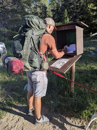


Starting out in the morning! Loaded up, signed in, and a quarter mile hiked when we realized we forgot to pack the map.


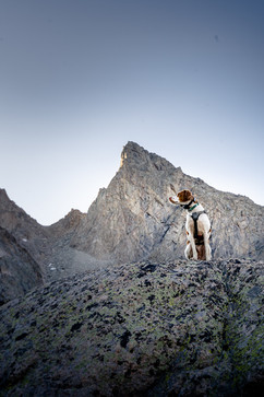
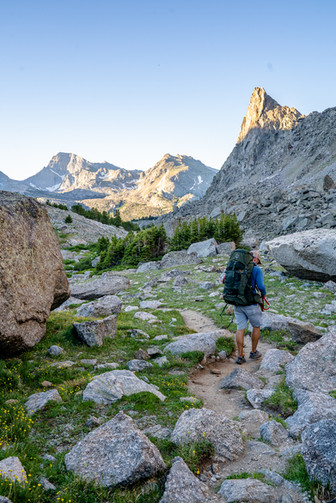
Day 1 was relatively easy when talking about incline. We started clockwise on the loop following the Fremont Trail. This portion of the trail was mainly wide open gorgeous meadows, lakes and stream crossings. Copper even took a nice dip in Mirror Lake. I'm a little sad looking at my photos that I didn't get a better picture of Dad's lake. This was our second lake in and I would love to go back and do a small weekend hike in to camp there in the future.


At about 9 miles we turned right, down the trail to Shadow Lake, and this is when the skeeters became ferocious! However, we were finally getting into the mountains and the views were definitely starting to pick up. We came across one river crossing too difficult to navigate and had to make the plunge and put our feet in. Brandon choose to go barefoot, but I had fallen in on an earlier crossing and already had wet shoes, so I just went for it again. I think I got the better end of the deal as the water was super cold and plenty of pointy rocks were hiding out ready to be stepped on.


We ended our hiking at about 2:30 PM at Shadow Lake. We rushed to set up our tent as the bugs swarmed. We spent the rest of the day hiding in the tent. We'd emerging every so often to check out if the bugs had eased and to cook some grub, but continued to get chased back into the tent. I did fight off the skeeters long enough to capture some of these pretty photos by Shadow lake near sunset.
Day 2
Date: July 22, 2019
Distance: 4.6 miles
Elevation gain: 1,421 ft
Average moving speed: 1.7 mile/hour
Start time: 6:30 AM
End time: 10:45 AM
Day 2 we planned a much shorter day. We only had about 4 miles to cover and we would be in the Cirque! We left early in the morning. Waking up right before sunrise, we hoped we'd get our camp packed up before the bug were awake. Note: the bugs are already awake by 5:30 AM....


We started the morning bushwhacking through the swampy meadows around Shadow Lake until we finally came across a solid trail. The morning light was gorgeous coming through the valley we were headed up. Check out those bugs in the last two photos above!


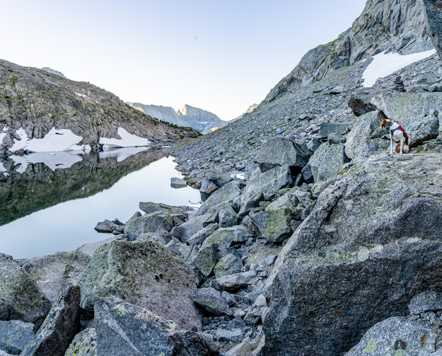
We followed the trail past three beautiful, small mountain lakes up to Texas Pass. Crossing over Texas Pass would be the steepest, most difficult part of our hike. We had to scramble up boulders and cross snow in order to reach the top. I'm extremely grateful that we packed our micro spikes. Although other hikers cross without, having my spikes on steep snow really gives me peace of mind.
Getting to the top was difficult, but oh so WORTH IT! If only it wasn't 10 miles into a hike and up super steep terrain, I'd love to take a couple up here for a sunrise session or elopement!
Going down the other sides of Texas pass was a bit less steep, but no trail existed. This portion of the trail was so trying that I didn't end up taking a single photo. So, you'll just have to take my word for the fact that going down was difficult but yet again gorgeous.


By the time we made it down Texas Pass my knees were so tired I couldn't even pull myself up one of the rocks as we crossed the river to where we'd camp. Insert laugh/crying emoji.
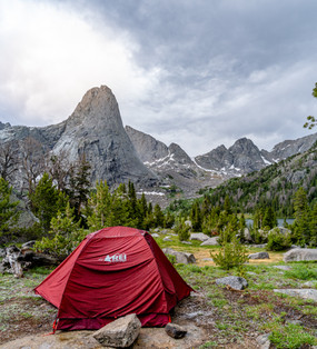
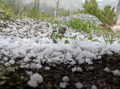
We reached our destination at Lonesome Lake by 11 AM and had the rest of the day to hang out in the amazing Cirque. This was exactly what we were hoping for, minus the bugs. Again, we spent a good amount of time hiding in the tent. We even got a little hail storm, but all in all, the views were too awesome for the bugs to keep us down. Did I mention I had something like 30 bites on the side of my leg and a** by this point?!
Day 3
Date: July 23, 2019
Distance: 9.21 miles
Elevation gain: 1,234 ft
Average moving speed: 2.3 miles/hour
Start time: 3:45 AM
End time: 10:15 AM
The next morning we woke up at 3:00 AM in order to pack up and be to the top of Jackass Pass by sunrise. I'm so grateful for Brandon being game to do crazy things to try and get the "perfect shot" of a location with me. We took off by 3:45 AM and reached the top of the pass in just 30 minutes. Needless to say, we were to the top of the pass way too early. We had planned for an hour hike and misremembered the time of sunrise, so we sat and cuddled in a sleeping bag from 4:45 till just before 6:00. LOL.


To my disappointment, the stars did not align, and the light did not filter into the Cirque as I had imaged. Can't say it wasn't gorgeous though, and seeing it in the soft morning light with little to no shadows was still breath taking.


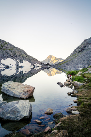


After getting down off the pass, we took the primitive/climber trail that led to my favorite lake of the trip, Arrowhead Lake. Arrowhead Lake was not necessarily a lake to camp at, but I loved the shape of the snow on the side of the rock and the pointed aspect of this lake. PLUS check out that reflection! Please don't judge my nerdiness with this topic, but I just can't get over how cool that reflection was. We scrambled over some large boulders again until coming back to the main trail and carried on our marry way. The trail was still a bit strenuous, going up and down around North Lake, but once we reached Big Sandy Lake it was all down hill from there. Literally, the final 5 miles were basically all flat with a very gradual downward slope. At this point there were beautiful meadows again, but I must have been too tired from our early take off to take many photos.


Comments